
2013 EWP Phase 2 Program Information
The Colorado Emergency Watershed Protection (EWP) Program for the 2013 Flood Recovery provided funding to implement emergency recovery measures to address hazards to life and property in watersheds impaired by the 2013 Colorado Flood. The program was funded and administered by the USDA Natural Resources Conservation Service (NRCS) and managed by the Colorado Water Conservation Board (CWCB) on behalf of the State.The Colorado EWP Program provided financial and technical assistance to local project sponsors to implement projects to protect life and property from future flood events.Technical assistance funds were available to support project design, cultural resources assessment, construction oversight, and other technical services.Financial assistance funds were made available for project construction according to the following cost share:75% - NRCS12.5% - CWCB12.5% - Local sources
In most of the flood-affected areas, watershed coalitions composed of public, private, and nonprofit stakeholders were charged with coordinating the identification, prioritization, and implementation of EWP projects.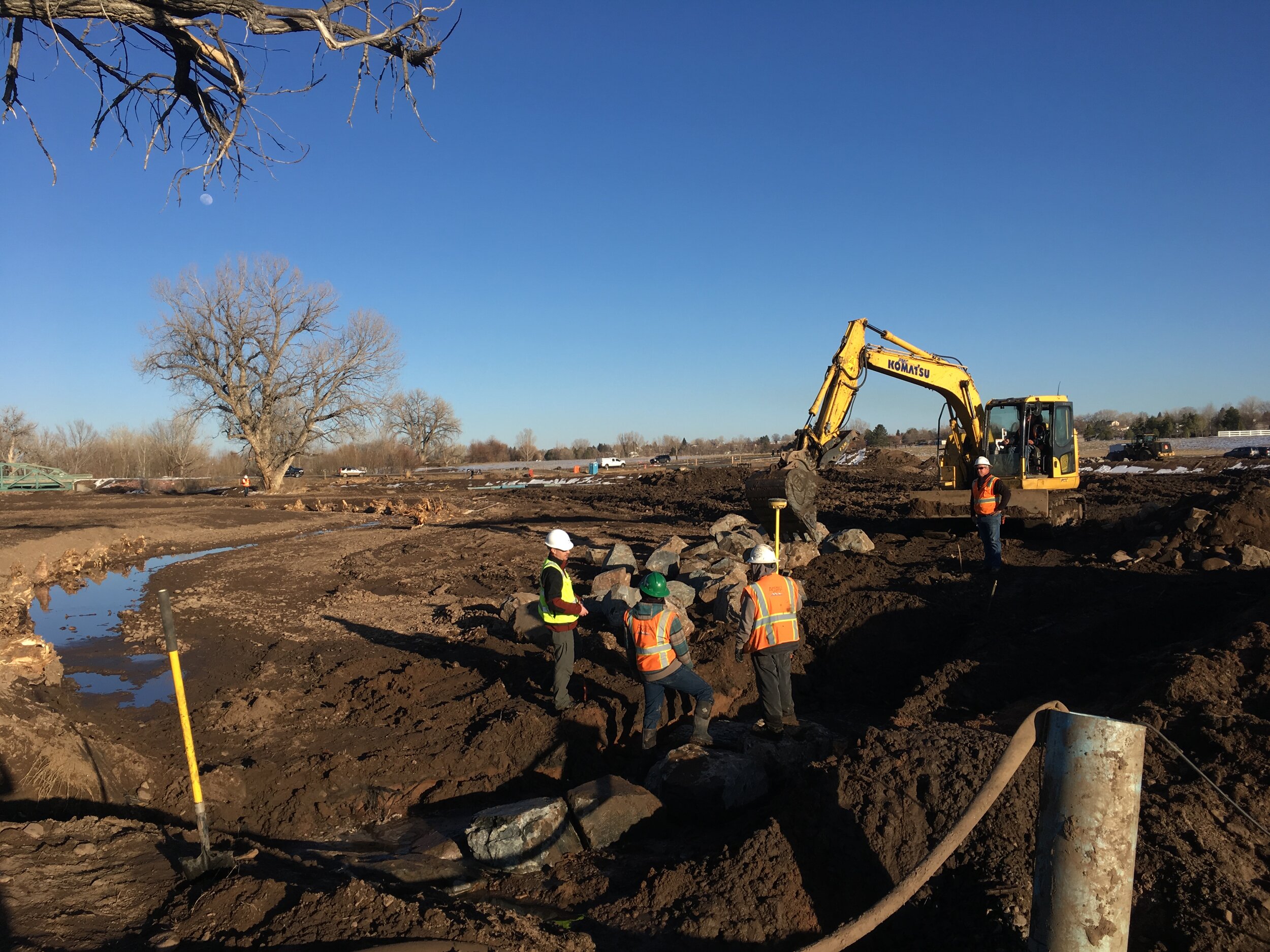
Vision and Goals
Colorado EWP Program - 2013 Flood Recovery Vision
Goals and Objectives
To implement watershed recovery projects that reduce risk to life and property, enhance riparian ecosystems, and generate long-term stream system resilience through a collaborative, watershed-based approach that incorporates the needs of diverse stakeholders.1. Reduce hazards and protect life safety and property
Improve property owner, community, and stakeholder understanding of hazards, risk, and the limitations of mitigation measures.
Educate stakeholders on natural flood protection services of healthy ecosystems.
Reduce hazards created by erosion and channel movement by enhancing stability of stream systems.
Design and construct projects that prioritize protection of private property, public infrastructure, and critical facilities.
2. Use federal and state funding effectively
Fund and implement projects that align with vision.
Leverage partners and other funding sources to increase buy-in and further impacts of investments.
Provide river restoration opportunities across watersheds and stream reaches.
Obligate funding throughout program life cycle, i.e. start spending soon.
Identify and prevent waste and duplication of effort.
3. Enhance the health and resilience of watersheds and stream corridors
Design and construct projects to improve geomorphic and ecological structure and function according to the Stream Function Pyramid framework.
Establish goals and objectives that identify the functional improvements being targeted by each project.
Design projects to contribute to improvements at individual site, stream corridor, and watershed scales.
Catalyze natural stream recovery and stabilization processes to minimize need for operations and maintenance.
4. Build capacity of watershed coalitions
Implement priorities identified in watershed master plans.
Provide training, resources, and other opportunities for coalition staff and members to improve capabilities.
Assist coalitions in engaging stakeholders, building relationships, and serving as valued educators.
Empower coalitions with responsibility for long-term monitoring and oversight of projects.
5. Advance a watershed-based approach to flood recovery
Develop and implement projects within a framework through which their long-term successes and failures can be monitored and analyzed.
Create resources to assist with replication and future implementation of similar programs.
Document and communicate lessons learned, challenges, and successes in terms of science and policy.
Master Planning and Project Prioritization
Following the 2013 Colorado flood events, the CWCB put together a team of State and Federal agencies to help communities strategize the short and long term stabilization and rehabilitation of stream channels. This stream task force quickly concluded that no single government entity had jurisdiction over the location of stream channels. The locations of the streams needed to be informed through a master planning process, and local watershed coalitions would be a critical component to implementing this process.Watershed Master Plans
The CWCB, in cooperation with the Colorado Department of Public Safety, developed a special release of the Colorado Watershed Restoration Program to provide funding for watershed master planning in flood-affected watersheds. The applicant criteria required that the planning be watershed based (i.e. transcend political boundaries) and that the applicants commit to inclusive, collaborative approaches involving diverse interests within the watershed.
Watershed Coalitions
As a result of the watershed master plan grant program, 8 watershed coalitions formed and 2 existing coalitions were supported to coordinate the planning process among diverse stakeholders including private landowners and residents, governments, and nonprofit organizations. The master plans identified and prioritized stream restoration projects in order to improve ecological conditions as well as protect life and property from flood hazards.

Damage Survey Reports
Watershed coalitions identified the highest priority projects (or project areas) from the master plans to be considered under the NRCS EWP Phase II. The NRCS completed Damage Survey Reports (DSRs) from August to November 2015 to determine EWP eligibility with the assistance/input of technical teams that included CWCB, coalition representatives and sponsors. DSRs document damage, broadly estimate treatment methods and costs, identify assets at risk, note environmental concerns, and eventually assist in determining a benefit-cost ratio of the proposed treatment. DSRs also serve to define project boundaries, describe the general scope of work, provide an initial cost estimate, and identify the assets that must be protected by the project(s). The EWP Damage Survey Report (DSR) is a foundational document for design teams as they scope and kickoff each EWP project design. DSRs determine the funding eligibility of projects for EWP Phase II. Although the design and details for construction work were determined by the project design team, the DSR is an important foundational document for each project. Guidance to design teams on how to interpret a DSR is highlighted here. Interpreting DSRs for Project Design Section 2: Environmental Evaluation
The Environmental Evaluation in the DSR is especially important to determine the project’s or group of projects’ existing conditions and proposed actions. The resource concerns are listed for each natural element (soil, water, air, plant, animal, or other), and an action to remedy the problem is proposed, using the SVAP2 scores. The Stream Visual Assessment Protocol version 2 (SVAP2) is a qualitative evaluation of the condition of aquatic ecosystems, and has specific scores for items such as bank stability. A low SVAP2 score (0, 1, or 2) indicates the reach is deficient in key categories and a high SVAP2 score (8,9, or 10) indicates the features in the reach are functioning in a relatively unimpaired way.
Section 2F: Economic Evaluation
The Economic Evaluation section lists all the assets, such as private properties, roads and access, pipelines, utilities, and businesses, that are required to be protected by the project. Additional assets, if they exist in the project area, can be protected with the project’s features. This section forms the benefit-cost ratio for the project. All eligible projects must have a benefit to cost ratio greater than 1, or a positive net benefit.
Engineering Cost Estimate
This Engineering Cost Estimate is an initial estimate of how much the damage survey team anticipates the proposed actions will cost. This budget will be refined as the detailed design is determined and finalized. The primary purpose of this section is to describe the scale of the proposed actions and to develop an overall project cost to use in the benefit-cost evaluations. The intent of the specific line items should be addressed in the project’s design; however, if design alternatives are available and better suited to the site, it is appropriate to substitute alternatives for those features. The specific quantities should be considered, but the values for each line item in this section are not binding.
Preliminary Scope of Work
For many EWP projects, a preliminary scope of work was developed to accompany the DSRs. (Please note that some EWP projects do not have a scope of work, but all have a DSR, which is required to complete a financial assistance agreement.) The preliminary scope of work includes narratives regarding the proposed work and budget items for each project and a project overview map with approximate locations of the assets and treatment types.
The project scope and budget will be refined as the detailed design is developed and finalized by the design team. The intent of the specific line items should be addressed in the project’s design. However, if design alternatives are available and better suited to the site, it is appropriate to substitute alternatives for those features. The specific quantities should be considered; however, the values included for each line item in this section are not binding.
DSR Glossary: Types of Proposed Actions
The following work items represent the majority of the construction components described in the DSRs.
Armored Resiliency: Rock riprap, or rock toe protection.
Bioengineering: Streambank protection using natural materials, such as toe wood, brush layering, coir fabric, live staking, “burrito wraps”, and plantings. The designers will have a lot of flexibility with bioengineering solutions.
Channel Bed Stabilization/Grade Control: In-stream structure, such as Rock J-Hook or Cross Vane.
Debris Removal: Removing dead trees, obstructions, trash, and other items obstructing channel flow.
Earthfill: Imported fill material for floodplain grade and channel shaping. Most sites have excess material from sediment deposition, and will not require imported fill.
Erosion Control Fabric: Coir, biodegradable fabric to protect disturbed streambanks until vegetation re-establishes. Specify for all grading of streambanks and bankfull benches.
Sediment Removal: Removing sediment from stream channel and re-shaping the channel. Excavation work to establish a floodplain, or to lower the grade to create a bankfull bench.
Seeding & Mulching: Re-establishing vegetation on all disturbed areas that will not be hard-surfaced.
Streambank Protection/Shaping: Grading bank to a flatter, stable slope, and if land is available, creating a bankfull bench. Must also have a planting component: seeding & mulching, trees & shrubs, and bioengineering. Erosion Control Fabric is also required to protect the surface while vegetation establishes.
Topsoil: Providing topsoil to help with re-vegetation.
Trees & Shrubs: Plantings along streambanks to provide future stabilization.

Information for Landowners
A unique aspect of the Natural Resources Conservation Service (NRCS) EWP program is that the funding can be used to protect assets and restore stream reaches along private property. In the Colorado EWP Program - 2013 Flood Recovery, private landowners were partners on many of the 74 eligible project areas. Watershed coalitions and project sponsors were critical in working with landowners to obtain permissions for projects, address questions and concerns, and keep them informed of project status.Benefits for Participating Landowners
Safety – Projects were designed to reduce risk to life-safety, property, and critical infrastructure from future flooding and erosion.
Holistic Approach – Projects were designed to consider the whole stream system and to minimize impacts to downstream properties, as well as address reach-wide water and sediment management issues.
Stream and Habitat Health – Projects improved ecological health of the stream corridor through the re-establishment of native plants and in-stream habitat for fish and aquatic life.
Shared Costs – Projects were funded through federal, state, and local sponsors, without capital cost to landowners.
Project Timeline: What Landowners Can Expect
Project Goals & Objectives
Understanding the problem and identifying the desired outcomes, or goals, for the project is a first step in the process. The goals outline how the project will contribute to the long-term safety and resiliency of the stream reach. Specific objectives clarify how the goals will be achieved, such as removing debris, stabilizing banks, or reshaping the channel.
Project goals and objectives must achieve the overall program vision and also take into account the input of landowners and stakeholders. Watershed coalitions help facilitate consensus on realistic and acceptable goals and objectives for each project.
2. Scoping
NRCS teams completed Damage Survey Reports (DSR) for projects in 2015. The DSR is the foundational scoping document and determines funding eligibility, describes the general scope of work, and identifies the assets that must be protected. Once contracted, a project design team reviews the DSR and holds a kickoff meeting and preliminary field assessment to refine the scope of work.
Watershed coalitions contact landowners to share information about the proposed project and the opportunity to participate. Signed permission forms must be obtained from landowners before the project design can be funded to proceed to more detailed phases.
3. Field Investigation & Data Collection

To develop a better understanding of the stream reach, the project design team researches best available reports and data to inform the analysis and design. This includes collecting information on stream flows, water diversions, soils, biological inventories, land surveys, and more.
4. Analysis & Design
The purpose of this phase is to analyze the benefits of different types of features and improvements to identify which are sustainable, cost effective, and best meet the goals and objectives of the project. The multi-disciplinary project design team draws upon a range of expertise to consider the river system holistically. The team analyses the system’s natural processes and flow dynamics, including the results of hydraulic computer modeling, to better understand the system’s opportunities and constraints.
5. Design Concept
The design concept plan lays out the project goals and objectives, data analysis, and design decisions. The plan set shows the location and purpose of treatments and improvements and recommends plantings. See the Design and Permitting to learn more about specific features and treatments likely to be incorporated in EWP projects.
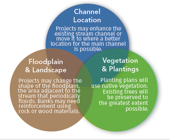
Project design teams, sponsors, and coalitions seek input from landowners at this stage to identify concerns and answer questions in the three following key topic areas: Channel Location, Floodplain & Landscape, Vegetation & Plantings. Ultimately, the project design team must determine the most appropriate and holistic approach to create a healthy river system and meet program goals and funding requirements.
6. Final Design
The project design team submits the final design plan to CWCB and NRCS for approval. The final design provides further detail on the plan set, moving the project closer to implementation by the contractor. The plan set includes an engineering report, details of specific treatments and features, a Quality Assurance Plan, and an Operations and Maintenance Plan.
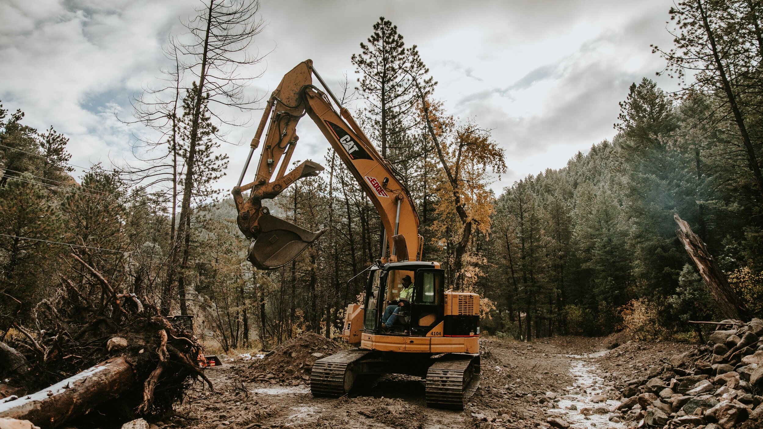
7. Construction
The onsite installation of the project typically lasts from one to six months. Project construction is dirty, noisy, and often inconvenient for residents. During this phase, keep in mind the importance of correct installation and the long-term benefits of the completed project.
During construction, the project sponsor and watershed coalition will keep landowners informed on the project schedule and progress.
8. Monitoring and Operations & Maintenance
The local project sponsor is required to perform inspections of the project for three years after construction to ensure it performs as expected. The project sponsor also may conduct annual monitoring of vegetation establishment and the stream channel to assess whether the project is fulfilling its identified goals and objectives. Vegetation will take several seasons to fully establish and thrive. Expect the stream channel to move and change. Channel adjustment is a healthy process that occurs as the river moves water and sediment over time. These projects are designed to minimize long-term maintenance needs and enhance the long-term stability and function of the entire river system.

River Restoration and Flood Resilience
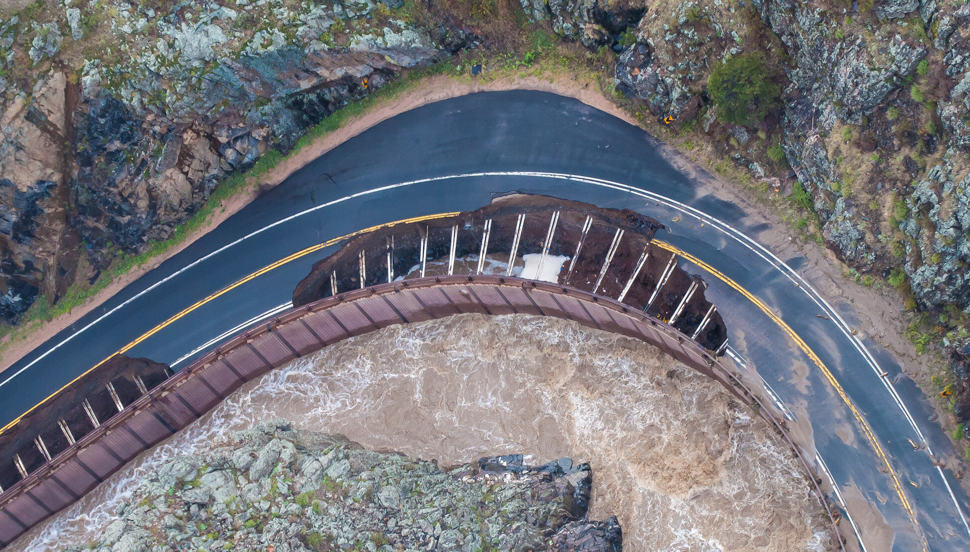
Rivers are constantly in a state of change, continually adjusting their size and shape in response to the amount of water and sediment in their watershed. Even “stable” rivers shift from year to year. Land use changes that significantly alter or overwhelm the ability of a river to transport water and sediment will cause the river to become unstable and increase the likelihood that catastrophic erosion or sedimentation occurs during a flood event.
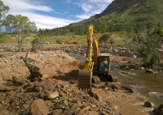
The purpose of river restoration is to restore rivers to a more naturally stable and functional condition by incorporating specific design features and treatments that encourage a river system’s natural processes. The 2013 Colorado Flood Recovery EWP projects are designed by multi-disciplinary project teams who draw from a range of expertise, including ecology, aquatic biology, geomorphology, hydrology, and engineering, to consider all the components of a healthy river system holistically.
Working with watershed coalitions, landowners, and other partners, project design teams establish project goals and objectives and identify restoration treatments to catalyze natural stream recovery processes that minimize damage and increase resiliency during future flooding.
Although EWP projects are designed to reduce risk, flood hazards will still exist in floodplain areas. Communities and property owners are responsible for preparing for flood events and mitigating long-term risk. Purchasing flood insurance; flood proofing, elevating, and setting back structures; and protecting the floodplain’s natural function are ways that landowners can protect their property and prevent future damage and loss.

A constrained river between two rip-rapped banks

A river with protection adjacent to homes, riparian, vegetation, and space for flows to expand

Watershed Coalitions
Colorado watershed coalitions work to restore healthy and resilient streams and watersheds through the collaboration of diverse stakeholders, including private landowners, governments, and nonprofit organizations. Coalitions identify funding, volunteers, and other resources to develop and implement projects with a wide range of objectives from enhancing riparian health and stream connectivity, to improving flood safety and water quality.Following the 2013 Colorado flood events, eight watershed coalitions formed and two existing coalitions were supported to coordinate the development of master plans prioritizing strategies for the short- and long-term stabilization and rehabilitation of damaged stream channels. Coalitions implemented the high priority projects identified in the master plans through a variety of funding sources, including the Emergency Watershed Protection Program.The Colorado Water Conservation Board and the Colorado Department of Local Affairs partnered to create the Watershed Resilience Pilot Program funded through the U.S. Department of Housing and Urban Development (HUD) Community Development Block Grants – Disaster Recovery and the State of Colorado. As part of the program, capacity building grants were used to fund full-time watershed coordinators and program assistants for coalitions in the flood affected watersheds, with the intent of planting the seed for the long-term establishment and success of these coalitions.Big Thompson Watershed Coalition
The Big Thompson Watershed Coalition (BTWC) is a coalition of government, private landowners, and non-profit organizations working to implement restoration of the Big Thompson River after the flooding in September 2013.
Estes Valley Watershed Coalition
EVWC is a non-profit organization whose mission is to "promote an ecologically healthy watershed that also seeks to maximize public benefits and minimize public risk, through community engagement and sound science." It is comprised of citizens of the Estes Valley serving voluntarily to support a safe and environmentally sound watershed for the community.
Coal Creek Canyon Watershed Partnership
The Coal Creek Canyon Watershed Partnership is a community coalition focused on post-flood recovery and resilience-building projects. CCCWP operates under the financial auspices of The Environmental Group, a 501(c)3 nonprofit entity.
El Paso County Regional Watershed Collaborative
El Paso County Public Information Office
Fourmile Watershed Coalition
The Fourmile Watershed Coalition is operating as the Watershed Coalition for Fourmile Creek. The Four Mile Fire Protection District is the Coalition’s fiscal agent. The Coalition is made up of stakeholders throughout the watershed including the US Forest Service, Boulder County, Xcel, Pine Brook Water and residents.
Lefthand Watershed Oversight Group
The Lefthand Watershed Oversight Group is a citizen-based nonprofit group working with residents and partners to improve water quality, watershed health, and watershed awareness along Left Hand, James, and Little James Creeks in Boulder County, Colorado. The Lefthand Watershed Oversight Group is financially supported by the Left Hand Water District and Boulder County.
Little Thompson Watershed Restoration Coalition
The Little Thompson Watershed Restoration Coalition (LTWRC) is a group of landowners and stakeholders working to restore the Little Thompson Watershed after the disastrous floods of 2013.
Middle South Platte River Alliance
The Middle South Platte River Alliance is a diverse group of stakeholders brought together following the 2013 floods to envision a healthier and more flood resilient corridor in north central Colorado. The Alliance specifically addresses a 20+ mile stretch of the South Platte River in Weld County between the confluence of the St. Vrain and Cache la Poudre Rivers.
Saint Vrain Creek Coalition
The Saint Vrain Creek Coalition is a locally driven, non-governmental, non-regulatory community-based organization that facilitates stewardship and restoration projects based on scientific analysis to improve watershed health and develop partnerships to plan, fund, and implement those projects.
Bids
Invitations to bid for individual projects and groups of projects, coming from project sponsors as well as watershed coalitions, were posted as they were released. Invitations to bid were also posted on Rocky Mountain Bids System at https://www.bidnetdirect.com/.Closed Invitations for Bids
Invitation for Bids:
St. Vrain Creek Restoration at McConnell Project
Issued by Saint Vrain Creek Coalition
Request for Bids:
Construction Services for Saint Vrain Creek Reach 3 Restoration
Issued by Boulder County Parks and Open Space
Request for Bids:
Gold Run Road Permanent Repairs and Gold Run Stream Restoration
Issued by Boulder County
Request for Proposals:
Ingram Gulch Restoration
Issued by Fourmile Watershed Coalition
Attachment: Design Plan Set
Request for Proposals:
State Highway 60 - NRCS Emergency Watershed Protection Project
Issued by Middle South Platte River Alliance
Request for Proposals:
EWP Restoration Projects for Fawn Valley and Elkhorn
Issued by Estes Valley Watershed Coalition
Addendum 1: Amended RFP and Pre-Bid Questions and Answers
Request for Proposals:
Wall Street Creek Restoration
Issued by Fourmile Watershed Coalition
Attachment: Design Plan Set
Invitation to Bid:
Construction Services for South St. Vrain Creek Restoration at Hall Ranch
Issued by Boulder County
Request for Proposal:
Lower Fourmile Creek Stream Restoration Project
Issued by Boulder County
Attachment A-1 (link to Dropbox folder)
Invitation to Bid:
Creek Rehabilitation Design Build for Apple Valley North
Issued by St Vrain Creek Coalition
Invitation to Bid:
Wagonwheel Gap Road and Fourmile Canyon Creek
Issued by Boulder County
Stream Restoration Construction Services for Left Hand Creek at Beilins-Hock Open Space Property
Issued by Boulder County
Invitation to Bid:
Creek Rehabilitation Design Build for Apple Valley South
Issued by St Vrain Creek Coalition
Invitation for Bids:
Jasper Lake River Restoration Project
Issued by the Big Thompson Watershed Coalition
Request for Proposals:
Big Thompson River and Fall River Restoration Projects
Issued by the Estes Valley Watershed Coalition
Invitation for Bids:
James Canyon Drive Permanent Repairs
Issued by Boulder County
Request for Proposals:
North 83rd Street Project
Invitation for Bids:
Plains Reaches: N 41st Street/Haystack/63rd/73rd/81st
Issued by the Lefthand Watershed Oversight Group
Invitation for Bids: Foothills Reaches:
Upper Left Hand/Streamcrest/Ranch
Issued by the Lefthand Watershed Oversight Group
Request for Proposals:
Coal Creek Canyon EWP Projects
Issued by the Coal Creek Canyon Watershed Partnership
Addendum 1 issued 01/04/17

Plant Collection
Revegetation to establish a healthy riparian corridor is fundamental to the success of watershed recovery projects. Multiple partners supported the Emergency Watershed Protection (EWP) program for the 2013 flood recovery by allowing the collection of native willow and cottonwood species from their public lands for the revegetation of recovery projects throughout the flood-affected watersheds. 
Technical Assistance Team
The Colorado Water Conservation Board (CWCB) contracted with Resilient Watershed Partners (RWP) in December 2015 to assist the State in implementing Phase II of the 2013 Colorado Flood Recovery NRCS Emergency Watershed Protection (EWP) Program. Resilient Watershed Partners provided the CWCB and local project sponsors with technical assistance services to complete projects that fulfilled the mission of the NRCS program and worked to achieve long-term objectives in watershed protection, restoration, and resiliency in Colorado.The RWP Team

Resilient Watershed Partners is a team of experts in stream restoration design and construction, floodplain management, and outreach and communications. Our work reflects our philosophy that naturally functioning, ecologically healthy watersheds and streams help protect life and property from natural hazards and create multiple benefits that enhance the long-term resiliency of communities and economies in Colorado. Team members are representative of 10 consulting firms and led by Enginuity Engineering Solutions. All team members are based in Colorado.
Technical Assistance Services
RWP supports the Colorado EWP Program on behalf of the Colorado Water Conservation Board (CWCB) in the above areas:


Archived Documents
Phase II Program Archive
Colorado EWP Program-2013 Flood Recovery Overview
This handout provides an overview of the Colorado EWP program purpose, vision, funding, timeline, and more.
FAQ: Colorado Emergency Watershed Protection Program FAQ 2.0, January 2016
This document provides answers to frequently asked questions about the EWP program, including project scopes and Damage Survey Reports (DSR), EWP project design and construction costs, local match requirements, permitting, and operations and maintenance.
FAQ: NRCS-CWCB Emergency Watershed Protection Phase II FAQ, September 2015
This document provides answers to frequently asked questions about the EWP funding process and requirements, the program’s intended outcome and timeline, and the role of coalitions and other stakeholders in EWP projects.
CWCB Letters to Coalitions
•July 7, 2015 LetterThe purpose of this letter was to update, inform, and clarify with the watershed coalitions the status of the Emergency Watershed Protection (EWP) program in terms of agreements, waivers, Damage Survey Report (DSR), timelines, and coalition priorities.
•August 21, 2015 LetterThe purpose of this letter was to update the watershed coalitions on the Damage Survey Report (DSR) process.
•November 23, 2015 LetterThe purpose of this letter was to update the watershed coalitions on the funding process.