CO EWP Phase 2 Constructed Projects (2013-2018)

Colorado took a holistic approach to stream system recovery following the 2013 floods by focusing on watershed scale recovery and incorporating long-term resiliency into every project. Download the program description handout to learn more about the State’s approach and the successful outcomes.
Accommodation statement: the State of Colorado is committed to providing equitable access to our services to all Coloradans. Please contact Chris Sturm (chris.sturm@state.co.us or 303-866-3441) for personalized accessibility assistance. We will contact you directly within three business days. Visit our accessibility webpage for more information and services, including AIRA, our free service for blind and low-vision users. Accessibility | Department of Natural Resources (DNR)

The Big Thompson River originates in Rocky Mountain National Park and flows through mountains, canyons, and plains until it reaches its confluence with the South Platte River near Evans, Colorado. The Big Thompson River and its major tributaries including the North Fork of the Big Thompson River, Buckhorn Creek, and the Little Thompson River experienced extreme flooding in September 2013.
The Big Thompson River also experienced a devastating flood in 1976, which remains the deadliest flood in the State of Colorado’s history.
Big Thompson River Flood Recovery Projects
Mountain Shadows 2
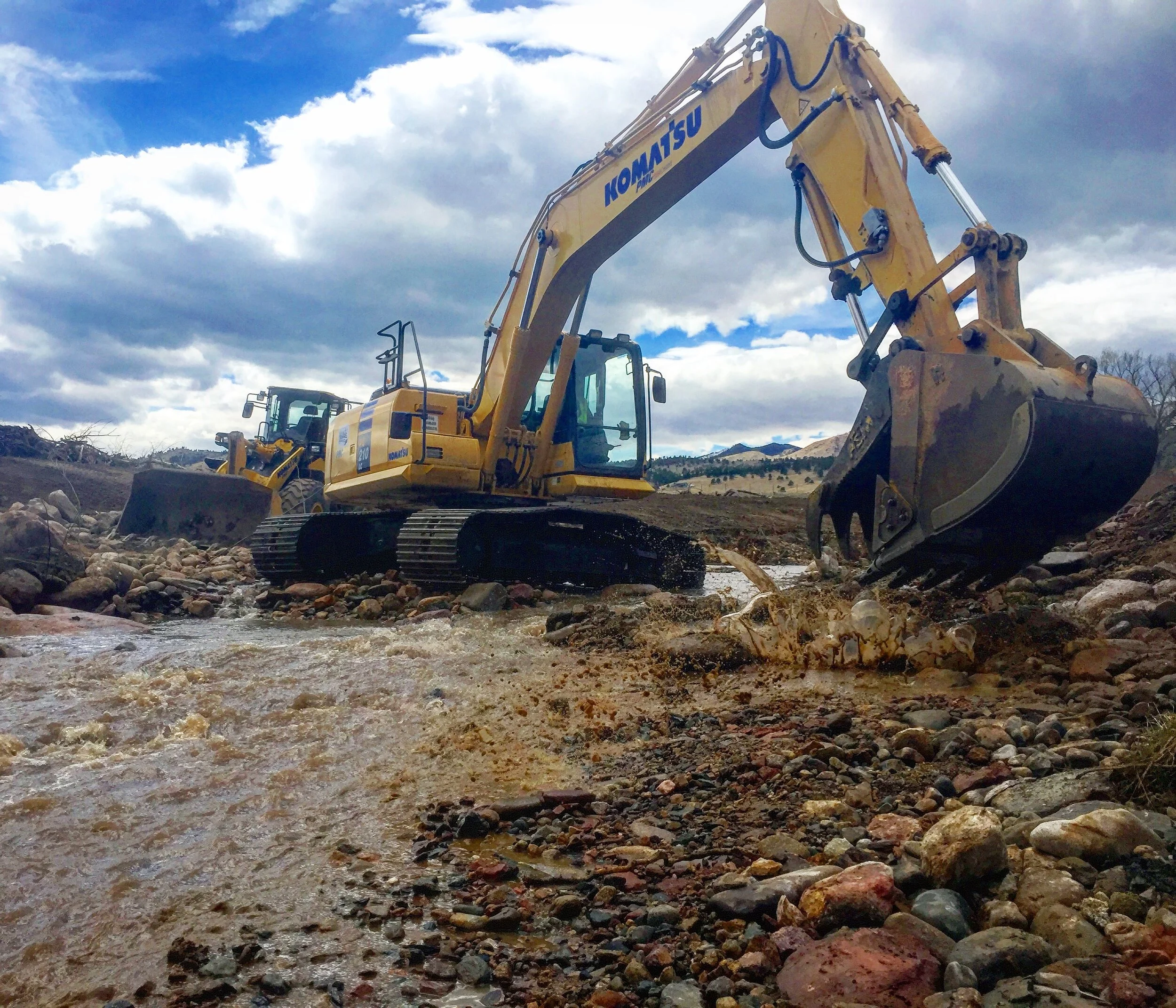
West Drake

Although only about 15 square miles in area, the Upper Coal Creek Canyon watershed in Jefferson and Boulder Counties was hit hard by the 2013 flood, which measured as the largest flood on record in the upper canyon. Within the Coal Creek corridor, nearly every bridge and culvert failed or was significantly damaged. The channel eroded significantly, leading to unstable slopes and failing banks through the central residential and commercial corridors.
Coal Creek Flood Recovery Projects

Estes Valley in Larimer County is home to three creeks, all of which experienced significant flooding in 2013: Fall River, Fish Creek, and the Upper Big Thompson River. The flooding in 2013 was devastating to homeowners
and businesses throughout the Estes Valley. Homes were damaged due to water, sediment, and erosion. Businesses suffered the effects of lost revenue for weeks, months, and even years after the storm. The Fish Creek corridor lost over 50% of its road and trail network, as well as the majority of the sewer and water lines.
Estes Valley Flood Recovery Projects

Fourmile Creek Watershed, a tributary to Middle Boulder Creek in Boulder County, has experienced a series of compounding disasters in the last decade. In 2010, the Fourmile Canyon Fire burned 23 percent of the watershed, destroyed more than 160 homes, and left the watershed vulnerable to flooding. Typical summer thunderstorms over the burned area in 2011 and 2012 produced flash floods and debris flows that transported a significant amount of sediment and debris into the creek corridor, plugging culverts and reducing the channel capacity. The following year, the September 2013 flood unleashed 13-18 inches of rain over the wildfire’s burn scar, inundating the canyon with floodwaters, sediment, and debris. The flood destroyed local roads and homes built within the active river corridor and damaged or destroyed nearly every crossing.
Fourmile Creek Flood Recovery Projects

Left Hand Creek originates in the Indian Peaks Wilderness and flows through the canyons and plains of Boulder County before joining Saint Vrain Creek in Longmont, Colorado. In September 2013, Left Hand Creek and its tributaries experienced a flood event that destroyed large sections of roads and public, residential, and commercial properties. The high peak flow, combined with the extended duration of the event helped to mobilize large amounts of sediment and triggered debris flows. The combination of water and debris magnified the damage in the creek corridor. Throughout the watershed, creeks migrated laterally, experienced significant deposition and erosion, cut new overbank channels, removed riparian vegetation, and destroyed or significantly damaged numerous waterlines, roads, embankments, bridges, and other infrastructure.
Left Hand Creek Flood Recovery Projects
Lower James Creek
Ranch
Upper Left Hand
41st Street Bridge
Blowout
Fike
Haystack Golf Course
Left Hand Canyon Dr

The Little Thompson River is a major tributary to the Big Thompson River and flows for over 50 miles from its headwaters in the Roosevelt National Forest to its confluence with the Big Thompson River near the town of Milliken. Located primarily in Larimer and Weld Counties, the Little Thompson has a relatively small watershed and difficult to access, as it is the only river in the Front Range that does not follow a major highway nor does it flow through any major towns. The September 2013 Colorado flood dumped an estimated 15 inches of rain over the Little Thompson headwaters and created an estimated peak discharge that exceeded historical measured flood levels by more than three times.
Little Thompson River Flood Recovery Projects

The Saint Vrain Creek Watershed – which includes South Saint Vrain Creek, Middle Saint Vrain Creek, North Saint Vrain Creek, and the main stem of Saint Vrain Creek – originates in Indian Peaks Wilderness and Rocky Mountain National Park. The flood recovery work mentioned here took place throughout the portions of Saint Vrain Creek in Boulder County, though the creek does flow through Weld County before entering the South Platte River north-east of Platteville, CO. In September 2013, the Saint Vrain Creek watershed experienced a catastrophic flood that caused numerous debris flows along the flanks of its steep mountains and changed the creek corridors overnight. The flood ripped through the steep canyon corridors tearing out trees and vegetation and carrying boulders the size of cars; bridges, culverts, and diversion structures located in its path were washed out. Large sections of Colorado Highway 7, US Highway 36, local roads, as well as public, residential, and commercial properties built along the Saint Vrain corridor were severely damaged or left stranded by the moving channel.
Saint Vrain Creek Flood Recovery Projects
Reach 3 Breaches

Fourmile Canyon Creek originates in the foothills west of the City of Boulder and has a total drainage area of approximately 10 square miles. The creek flows east and south through the City of Boulder and eventually into Boulder Creek. The work completed on Fourmile Canyon Creek was in the foothills west of the City of Boulder in unincorporated Boulder County.
Fourmile Canyon Creek Flood Recovery Projects

In September 2013, the segment of the Middle South Platte River that flows through Weld County, including the municipalities of Milliken, Evans, and LaSalle, experienced a flood event that resulted in significant damage to the river corridor and surrounding communities. The Middle South Platte River receives flow from All the above drainages before meeting the Poudre River near Greeley and ultimately heading to the northeast and into Nebraska. In numerous locations, the floodwaters scoured away waterlines, septic systems, roads, and flood-control structures. Within the river corridor, the South Platte experienced significant sediment deposition creating new and expanding existing point and mid-channel bars, and abandoning the pre-flood channel in numerous places by breaching its banks.
Middle South Platte Flood Recovery Projects

Upper Fountain Creek drains the western slopes of the Rampart Range including a majority of the Waldo Canyon Fire area, and the northeastern slope of Pikes Peak. Projects were constructed on several tributaries to Fountain Creek near Manitou Springs as well as on Rock Creek near Cheyenne Mountain State Park and two small tributaries to Monument Creek west of the City of Colorado Springs.
Fountain Creek Flood Recovery Projects
Ruxton Walls
May Museum
North-to-North